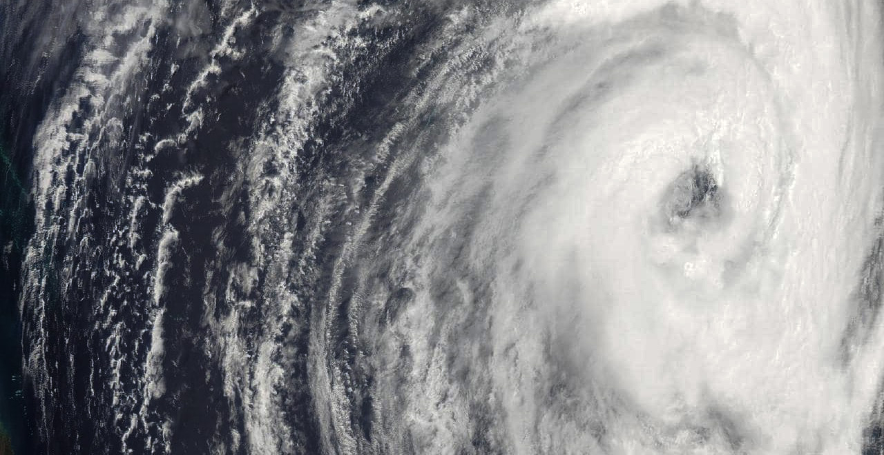
Cyclone Oma heading towards the Fraser Coast
22 Feb 19 – Satellite Image
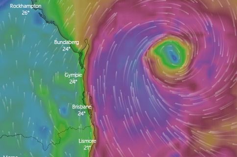
Cyclone Oma, a category two cyclone, currently around 600km out over the ocean is likely to be hitting the Fraser Coast this weekend. Bureau of Meteorology (BOM) expects the cyclone to hit coastal areas within the next few days but there was still some uncertainly over its exact direction. Oma has been proving difficult to predict, mainly because of the lack of weather observations within the ocean, but it does seem likely that the Fraser Coast will see some extreme weather this weekend.
- Severe weather warnings have been issued
- The Fraser Coast local Disaster Managment Group has moved its status to ALERT
- Flood watch has been issued by BOM for the entire Queensland South coast from Gladstone to the Gold Coast.
Fraser Coast could see 400mm of rain, Sunshine Coast receiving about 200mm, with Brisbane likely being impacted too. Forecasting waves between five to eight meters. Coastal flooding is expected because of the timing with the full moon tides, which will see the highest tide for the year. High tide is expected at 10:40am tomorrow (Fri 22 Feb). Authorities have already closed several beaches and started dumping extra sand in preparation. The coast could see gusts over 100km.

High Tide BOM Warning
Gale Warnings for the following areas:
- Hervey Bay
- Capricornia Coast
- Fraser Island Coast
- Sunshine Coast Waters
- Moreton Bay
- Gold Coast Waters
There are flood weather warnings for:
- lower Flinders River
- Norman River
- Eyre Creek
- lower Diamantina River
- Cooper Creek
- Thomson River
Queensland State Manager Bruce Gunn said the effects of Cyclone Oma are already being felt along the Queensland coast. “Surf and swell conditions will be hazardous for coastal activities such as rock fishing, boating, and swimming and many beaches are already closed for public safety,” he said.
“Gale force winds are possible for exposed coastal beaches, combined with heavy rainfall. The Bureau has issued a Flood Watch from Gladstone to the New South Wales border. Forecast rainfall totals are largely dependent on the cyclone track, and there still are a wide range of scenarios at this point,” said Mr Gunn.
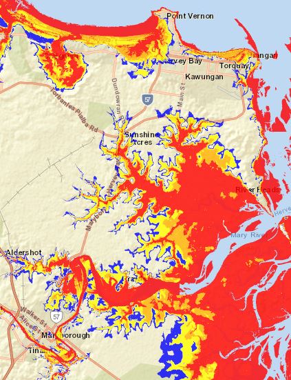
Fraser Coast Flood Map
Some pre-cyclone actions you might want to consider
- Clear your property of any loose material and trim any loose shrubs/tree branches
- Check with the council whether your home/building has been built to cyclone standards
- Top up fuel in your vehicles and park in a secure location
- Keep a list of emergency numbers on display
- If you area is prone to flooding, go to your nearest evacuation centre
- Prepare for possible power outage
- Prepare for flooding..
Sandbag Filling Points
The following sandbag filling points are being open (BYO shovel and labour)
- Burrum Heads SES Depot (223-231 Burrum Heads Road) -Thur and Fri 14:00 to 17:00
- Maryborough SES Depot (Reed Ave) -Thur and Fri 08:00 to 12:00
- Tiaro SES Depot-Thur (Copenhagen Street) -10:00 to 12:00 hrs
- Glenwood Community Centre Sat-10:00 to 12:00 hrs
- Hervey Bay aquatic centre (204a Boundary Road) -Thur and Fri 10:00 to 12:00
- Howard Council depot (Steley Street) -Sat 10:00 to 12:00 hrs
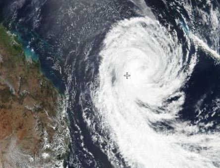
Prediction for Saturday
Recommend Actions if your area is impacted
- Disconnect any unnecessary large electrical items and turn off your gas supply
- Stay indoors away from windows and keep children indoors
- Don’t walk, ride your bicycle or drive through flood water, and keep clear of creeks and storm drains
- Check your property regularly for erosion or inundation by sea water, and if necessary raise goods and electrical items
- Stay out of the water and stay well away from surf-exposed areas
- If your building starts to break apart, protect yourself with mattresses under strong solid fixtures
References:
- BOM Media Release: http://media.bom.gov.au/releases/642/cyclone-oma-to-approach-the-southeast-queensland-coast-this-weekend/
- BOM weather warnings: http://www.bom.gov.au/qld/warnings
Useful links:
- Council disaster page: disaster.frasercoast.qld.gov.au/
- Disaster Management: https://www.frasercoast.qld.gov.au/disaster-management
- Council disaster map: https://mapping.frasercoast.qld.gov.au/maps/?project=DisasterMgmt&module=Storm%20Surge%20Evacuation%20Zones
- Wind Map: www.windy.com/?-22.228,156.006,5
- Zoom Earth: https://zoom.earth/#-24.162791,157.639283,6z
- Emergency numbers: https://thebeacon.com.au/fraser-coast-emergency-contacts/
Emergencies: SES on 132 500
Understanding the Tropical Cyclone Category System
- CATEGORY 1 (tropical cyclone)
- Negligible house damage. Damage to some crops, trees and caravans. Craft may drag moorings.
- A Category 1 cyclone’s strongest winds are GALES with typical gusts over open flat land of 90 – 125 km/h.
- These winds correspond to Beaufort 8 and 9 (Gales and strong gales).
- CATEGORY 2 (tropical cyclone)
- Minor house damage. Significant damage to signs, trees and caravans. Heavy damage to some crops. Risk of power failure. Small craft may break moorings.
- A Category 2 cyclone’s strongest winds are DESTRUCTIVE winds with typical gusts over open flat land of 125 – 164 km/h. These winds correspond to Beaufort 10 and 11 (Storm and violent storm).
- CATEGORY 3 (severe tropical cyclone)
- Some roof and structural damage. Some caravans destroyed. Power failures likely.
- A Category 3 cyclone’s strongest winds are VERY DESTRUCTIVE winds with typical gusts over open flat land of 165 – 224 km/h.
- These winds correspond to the highest category on the Beaufort scale, Beaufort 12 (Hurricane).
- CATEGORY 4 (severe tropical cyclone)
- Significant roofing loss and structural damage. Many caravans destroyed and blown away. Dangerous airborne debris. Widespread power failures.
- A Category 4 cyclone’s strongest winds are VERY DESTRUCTIVE winds with typical gusts over open flat land of 225 – 279 km/h.
- These winds correspond to the highest category on the Beaufort scale, Beaufort 12 (Hurricane).
- CATEGORY 5 (severe tropical cyclone)
- Extremely dangerous with widespread destruction.
- A Category 5 cyclone’s strongest winds are VERY DESTRUCTIVE winds with typical gusts over open flat land of more than 280 km/h.
- These winds correspond to the highest category on the Beaufort scale, Beaufort 12 (Hurricane).
Cyclone Twitter feed..
Dawn over twin tropical cyclones across the equator, Cyclone #Oma 🌀and tropical storm #Wutip 🌀 intensifying to likely Typhoon. #CycloneOma #TyphoonWutip pic.twitter.com/uvBtC4OZpg
— YouStorm (@YouStormorg) February 20, 2019
Latest track confirms the WATCH area for #CycloneOma remains in place for coastal communities from #Bundaberg to #Ballina in northern NSW including #Brisbane #SunshineCoast and #GoldCoast. 4-6m waves being recorded offshore of North Stradroke Island: https://t.co/nwGVYbCU0S pic.twitter.com/BblrLgWK3S
— Bureau of Meteorology, Queensland (@BOM_Qld) February 21, 2019
Have you picked up a copy of our magazine?
Available at Hervey Bay Stockland’s, Night Owl, Food n Groove, Maryborough Art Gallery, and various other newsagents throughout the Fraser Coast..
There’s more!
Recent Posts / View All Posts